

Building and Measured Building Surveys
Floor plans, sections and elevations
Hannaway & Hannaway
specialize in providing measured building surveys of buildings old or new.
We offer a cost effective solution to provide measured floor plans, elevations
and sections. Our survey is conducted and drawn up in Real Time using
the latest non contact laser measurement systems linked to handheld computers.
We can also offer elevation extraction from terrestrial digital photogrammetry
providing you with Ortho rectified photographic elevations as well as traditional
line elevations.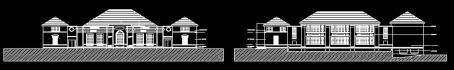
You may wish to consider us when next you require any of the following
- Floor plan survey
- Elevation survey
- Sections
- Level survey
- Monitoring structural movement
- Rectified photography
- Photogrammetry
- Net internal area NIA surveys
All Surveys are carried out in accordance with RICS Code of measurement.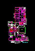
The completed survey is available in both hard and soft copies and comprise of plans, sections and elevations as well as rectified ortho-photos, if requested.
2d and 3d heighted data related to a baseline or benchmark can also be output for all points surveyed which eliminates the need for the commissioning client to scale off the drawings as the spatial data relationship of all elements is clearly visible.