

Geographic Information System (GIS) and Asset Location
 With
the advent of ever more sophisticated mapping systems and the continuing need
for assets to be accurately geographically located and updated, we are ideally
placed to provide a comprehensive data collection service, utilizing our centimeter
accurate GPS receivers coupled with hand held laser measuring
devices.
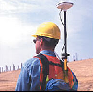
With
the advent of ever more sophisticated mapping systems and the continuing need
for assets to be accurately geographically located and updated, we are ideally
placed to provide a comprehensive data collection service, utilizing our centimeter
accurate GPS receivers coupled with hand held laser measuring
devices.
You may wish to consider us when next you require any of the following.
-
Asset surveys
-
GIS data capture
-
Manhole survey
-
Lamp post surveys
-
Bus stop surveys
-
Utility surveys
-
GPS surveys
Most GIS software systems are supported ESRI Arc-Info, Map-info, Autodesk MAP, etc. You should contact us regarding Asset Management Data Collection solutions for Utilities, water, gas or associated infrastructure development schemes, we would be very happy to advise or submit a price.